


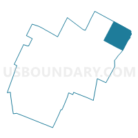
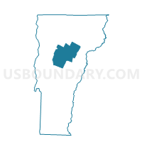
Cabot Voting District, Washington County, Vermont
About
Outline

Summary
| Unique Area Identifier | 680905 |
| Name | Cabot Voting District |
| County | Washington County |
| State | Vermont |
| Area (square miles) | 38.53 |
| Land Area (square miles) | 37.26 |
| Water Area (square miles) | 1.27 |
| % of Land Area | 96.70 |
| % of Water Area | 3.30 |
| Latitude of the Internal Point | 44.38328790 |
| Longtitude of the Internal Point | -72.28740080 |
Maps

Graphs
Select a template below for downloading or customizing gragh for Cabot Voting District, Washington County, Vermont


Neighbors
Neighoring Voting District (by Name) Neighboring Voting District on the Map
- Calais Voting District, Washington County, VT
- Danville Voting District, Caledonia County, VT
- Hardwick Voting District, Caledonia County, VT
- Marshfield Voting District, Washington County, VT
- Peacham Voting District, Caledonia County, VT
- Walden Voting District, Caledonia County, VT
- Woodbury Voting District, Washington County, VT
Top 10 Neighboring County Subdivision (by Population) Neighboring County Subdivision on the Map
- Hardwick town, Caledonia County, VT (3,010)
- Danville town, Caledonia County, VT (2,196)
- Calais town, Washington County, VT (1,607)
- Marshfield town, Washington County, VT (1,588)
- Cabot town, Washington County, VT (1,433)
- Walden town, Caledonia County, VT (935)
- Woodbury town, Washington County, VT (906)
- Peacham town, Caledonia County, VT (732)
Top 10 Neighboring Place (by Population) Neighboring Place on the Map
Top 10 Neighboring Elementary School District (by Population) Neighboring Elementary School District on the Map
- Hardwick School District, VT (3,010)
- Calais School District, VT (1,607)
- Walden School District, VT (935)
- Woodbury School District, VT (906)
- Peacham School District, VT (732)
Top 10 Neighboring Secondary School District (by Population) Neighboring Secondary School District on the Map
Top 10 Neighboring Unified School District (by Population) Neighboring Unified School District on the Map
- Twinfield Union School District 33, VT (2,831)
- Danville School District, VT (2,196)
- Cabot School District, VT (1,433)
Top 10 Neighboring State Legislative District Lower Chamber (by Population) Neighboring State Legislative District Lower Chamber on the Map
- Lamoille-Washington-1 State House District, VT (7,986)
- Washington-6 State House District, VT (4,438)
- Caledonia-Washington-1 State House District, VT (4,361)
- Caledonia-2 State House District, VT (4,161)
Top 10 Neighboring State Legislative District Upper Chamber (by Population) Neighboring State Legislative District Upper Chamber on the Map
Top 10 Neighboring 111th Congressional District (by Population) Neighboring 111th Congressional District on the Map
Top 10 Neighboring Census Tract (by Population) Neighboring Census Tract on the Map
- Census Tract 9570, Caledonia County, VT (4,275)
- Census Tract 9540, Washington County, VT (4,264)
- Census Tract 9577, Caledonia County, VT (3,010)
- Census Tract 9578, Caledonia County, VT (2,928)
- Census Tract 9541, Washington County, VT (2,513)
- Census Tract 9576, Caledonia County, VT (2,196)
Top 10 Neighboring 5-Digit ZIP Code Tabulation Area (by Population) Neighboring 5-Digit ZIP Code Tabulation Area on the Map
- 05843, VT (2,556)
- 05658, VT (1,402)
- 05647, VT (1,141)
- 05873, VT (675)
- 05681, VT (458)
- 05862, VT (356)